From The Dirt:
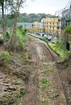
A bit more than 10 years ago, Ryan Gravel, a Georgia Tech architecture and urban planning master’s student, delivered a whopper of a thesis. His vision was to transform the mostly abandoned railroad lines that circle Atlanta into a new network of transit, parks, and pedestrian and bike trails. While that vision would have died in other cities, it actually took root in Atlanta and is now becoming a reality. Seven years into the wildly ambitious Atlanta Beltline, a 25-year, $3 billion project, more than 640 acres of land have been acquired and tens of millions raised. By the end of the project, more than 22 miles of modern streetcars, 1,300 acres of new parkland, and 33 miles of bike and pedestrian trails will make Atlanta a far more sustainable, livable, and inclusive place. That streetcar will connect some pretty down-on-their-heels neighborhoods to wealthy ones, creating access to new opportunities for poorer Atlantans. The new infrastructure, parks, and trails will hopefully be the tipping point that will get Atlantans out of all those cars. To make this transformation happen, some $1.8 billion will be spent on the transit, $500 million on parks, and $250 million on trails.
In a bus tour of the Beltline as part of the E.P.A.’s Brownfield conference, Heather Hussey-Coker and Lee Harrop explained how the unique industrial history of Atlanta laid the foundation for the Beltline and how a wide-ranging coalition of organizations, government agencies, and private sector firms have made the project happen.
After he completed his thesis, Gravel formed the Friends of the Beltline and started shopping the idea around Atlanta. Many presentations later, support started to build. The Trust for Public Land came in and did a research study that showed how the Beltline could become Atlanta’s Emerald Necklace. Soon thereafter, then Atlanta Mayor Shirley Franklin commissioned a study to determine whether the Beltline could be financed with a tax allocation district (TAD). The city found that it would raise more than 60 percent of the total cost so decided to move forward with that approach.
A TAD is basically “tax increment financing.” As Kevin Burke, ASLA, senior landscape architect for the Beltline, explained, imagine the tax value of a property goes up with rising property values. That incremental tax revenue is set aside for specific projects like the Beltline. The problem that came later was that the real estate market in Atlanta crashed, “skewing market projections of how much money the TAD would provide the Beltline.” Burke said this is the main reason “we have only delivered 60 acres” of parkland out of the planned 1,300-acre system of greenways and parks.
On top of that, the use of a TAD for the Beltline was delayed because a local resident sued, arguing that the public school portion of local taxes couldn’t be used to finance the Beltline. The case went all the way to the state supreme court, which just recently sided with the Beltline. Then, in a state-wide referendum, the voters of Georgia decided that school districts could opt in to TADs.
The Beltline is back on track though, largely because of an “aggressive fundraising campaign,” said Burke, which has brought in more than $40 million. Now in year six of the TAD, that measure will deliver money to the Beltline over the next 19 years. In reality, Burke said this will mean about “53-55 acres of parkland should be built each year.”
Hussey-Coker said the original railroad tracks that the Beltline follows were used to circulate industrial goods from manufacturing facilities on the outskirts of Atlanta to the city’s downtown, where they were then moved to other parts of the country. Residential areas then grew up around those industrial centers. “Beltlines were created to avoid the industrial downtown,” which was viewed as not a great place to live. The circular Beltline around the city served to “pause development for a long time.” Within its boundaries, “trolley suburbs” were created.
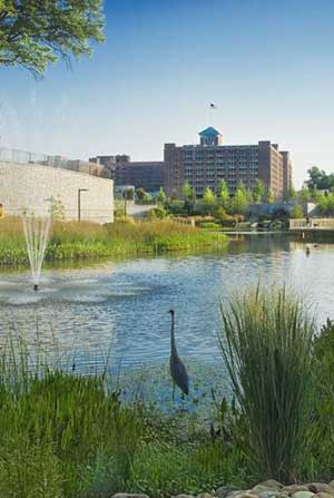
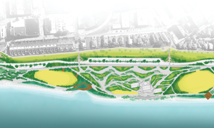
 The parkland that has been added already is pretty spectacular. As the bus drove past, everyone oohed and aahed over the new historic 4th ward park, a Sustainable Sites Initiative (SITES) pilot project that has spurred $400 million in development around it. In a clever landscape architecture design, the Beltline team created a new basin that doubles as a park. An example of smart multi-use infrastructure, the new park, which cost $50 million, is designed to flood in severe storm events. When not flooding, there are ledges for exercise, with a theatre in the center. “We built a 17 acre park and a new piece of infrastructure for $50 million.”

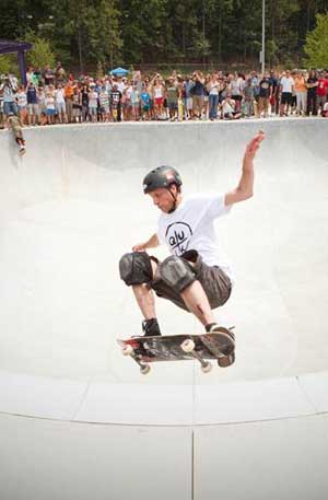
 The park also leaps and bounds through the neighborhood, with additional smaller pieces dotted through the community. The nearby skatepark, which legendary skater Tony Hawk helped finance to the tune of $25,000, looked like a skater’s paradise. Burke said a new space for beginning skaters will be added soon, given what’s there now is for pretty advanced stuff.
 Design work has already begun on a number of other parks. James Corner Field Operations, designers of the High Line, and Perkins + Will, originally created the “25 percent-level designs,” said Harrop, creating the basic language of the greenways, parks, and trails. While Perkins + Will is doing more design work, Field Operations is no longer involved. Request for qualifications are going out for each individual park. While Burke said some $75 million has been spent so far – on parks and trails, there’s a long ways to go over the next 10-15 years. He said he’s already working 10-12 hours days getting new parks online.
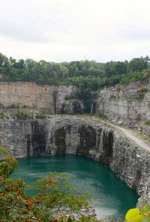
One exciting park will be appearing soon at the Bellwood Quarry, an old quarry that the city bought in 2006. There will rise a new reservoir, the focal point of the new Westside Reservoir Park. In a unique partnership with the city’s department of watershed management and parks department, the Beltline will develop the park around the reservoir while the city will ensure the security and safety of the water supply. Harrop also told us that a herd of American bison, which are actually native to the area, may be imported and be used to organically amend the soils. The Beltline crew likes to set herbivores on their plant problems: goats were recently let loose on kudzu in some spots and sheep on poison ivy in others.
 Still other areas near the Beltline targeted to become parks are currently brownfields. Just west of University Avenue, in the southwest segment of the Beltline, a property next to the former State Farmer’s Market, which is now a wreck, will rise like a phoenix from the ashes and become a new 5-6-acre urban farm. To make way for this transformation, several layers of asphalt were removed, along with old gas tanks, axles, and transmission tanks. Harrop said the area will be restored from an abandoned industrial site to its original use as an agricultural resource for the neighborhood. He remarked on the “poetry” of that transformation.
 The transit corridor itself will rise and fall through the city. Burke said it will look much like the St. Charles street car line in New Orleans. There will be grass below and on the sides of the tracks. Like in New Orleans, Atlantans will be able to walk or jog near the tracks. “It will be a porous transit line.” The big challenge, though, is that much of the Beltline isn’t at grade; much of the network will be above or below street level. Every street that crosses the line will offer an access point. The transit line itself will stop every half to quarter mile. While there are 10 at-grade access points, there will be lots of walking up and down stairs and ramps to get to the line. Burke said “it’s an extreme challenge to design access so that people don’t feel like they a deserve a piece of cheese when they reach the end of the ramp.”
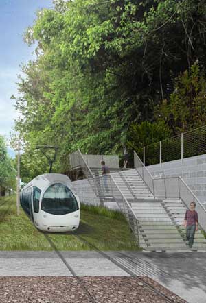 Once people find their way to the streetcar corridor, they will find a 14-foot concrete bike and pedestrian trail, said Hussey-Coker. The walking trail will run alongside the streetcar. In most places, there will be enough room between the two networks so that no physical divider between them will be needed. In the case where they are just 7-feet apart, the design team plans to add in low shrubs or fences.
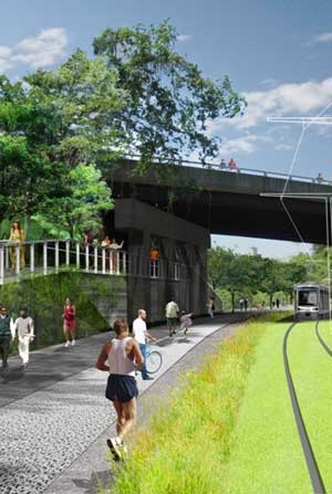 In some parts, interestingly, the trail actually diverges from the streetcar line. “The trail will be nearby but it’s not always side by side.” The trails are in fact designed to meander a bit to “connect isolated green spaces” near the light rail line. To ensure bicyclists can also easily access the trail, entrepreneurs in the city are looking at opening bicycle rental shops at key points. There is a feasibility study underway for a bike share program as well. “Before we can build the bicycle infrastructure, we need to build a bicycle culture,” said Hussey-Coker.
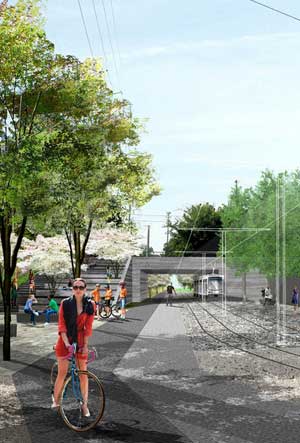 A lighting scheme is being designed to enable access at night and enhance security. The team decided against security call boxes along the trail, but they will be in the transit stations. Harrop said the cost of adding security call boxes along the entire 22-mile line would have been prohibitive, plus “everyone has cell phones these days.” The Atlanta Police department is already putting together the Path Force, a team dedicated to patrolling the parks, trails, and nearby neighborhoods. In the beginning of the planning process, there were some fears that the Beltline could be used as a “criminal corridor, used for bad stuff.” But the market is saying something different. Harrop noted a marked improvement in the housing market in Beltline neighborhoods and said bidding wars for residences right off the line are becoming more frequent. In fact, speculators are buying up vacant properties along the Beltline in some areas, seeing opportunities to make lots of money.
The landscape design itself, which was informed by the work of Perkins + Will and James Corner Field Operations, will be built out in parts by Trees Atlanta, a local tree-planting organization. Some sections will be like an arboretum, while others will be a more straight-forward greenway. In many areas, the landscape itself needs to be cleaned up, with invasive plants removed and basic environmental remediation. Groups in the 45 neighborhoods the line transects are able to Adopt the Beltline and organize clean-up crews. The Beltline seems to have done an excellent job at involving the many diverse local communities in both planning and upkeep. “There have been no protests about the Beltline.”
 But the big question may be: Can this new streetcar and set of trails really get Atlantans to move around the city in ways the existing infrastructure has not? The Beltline team is serious about providing other forms of mobility, but will they succeed in uprooting the car culture? Can they get Atlantans to think it’s cool to bike to work, walk trails every day, or take the streetcar to connect to a subway or bus?
The relatively new MARTA subway system (at least in comparison with NYC and Chicago) seemed barely used when this blogger rode it about 10 times, with stations and trains largely empty. Local riders looked like they were among those unlucky enough to not own a car. There were some tourists and business travelers coming to and from the airport. The reality is that the 10-county Atlanta region has some 4.2 million people, yet just 200,000 use the MARTA subway each day, despite the billions that have been spent on the project. Another 200,000 use the bus system, which this carless blogger waited almost an hour for one day. When I went into a store and asked one shop owner how to get back downtown on the bus, she just laughed, saying that “nobody rides the bus.”
As the new infrastructure comes in, the Beltline team, Atlanta city government, non-profits, and private sector firms, will need to work together to change the culture of the city, so that this beautiful re-envisioning of Atlanta’s historic infrastructure is actually put to good use.
Learn more about the Beltline master plan and next steps and see more photos.



Finding out about projects like this, while living in Memphis just depresses me. Yes, I know we have the Greenline, BassPro project going, Crosstown, Cooper Young, Overton Square, and yes, they are all great projects. However, sometimes I feel that I will never see what Memphis can become until I’m pushing 60 years old. Do I want to spend the rest of my 30’s hoping, wishing, praying that Memphis will evolve into a more progessive metropolitan city? After spending time in other cities in the past year-Baltimore(!!!), DC, Dallas, Charlotte, Nashville, heck even Little Rock, it just appears that Memphis lacks the care, and is structurely(in most visable areas) stuck in the 80’s. In each of those cities, as I commuted about, you always got a sense that you were in a “city”. Maybe its because those cities major expressways/highways actually go through and around its downtown? You can also tell that those cities care about their own image as well. In the cities core, sidewalks were freshly repaired, landscaped properly, buildings maintained. I made it a point to observe the various exits inside each cities core(downtown) and how each exit was carefully groomed and maintained. Rarely saw any trash anywhere, yes there were a few vacant lots, but for the most part everything was well-maintained.
Almost every entry way into Memphis is under developed, trashy, or dirty(I-55 Shelby Drive, Airways entry, I-40 E from bridge, I-40 E as you enter city near Sycamore View), and you basically can travel through Memphis WITHOUT seeing an actual structure, high rise, skyscrapper, etc. Just venting.