Memphis’ parkways, the great emerald necklace that encircles the historic heart of the city, is perhaps one of the best large planning projects this city has ever undertaken. Designed by George Kessler more than a century ago to connect the city’s two great parks he had also been commissioned to design (Overton and Riverside), the parkways have endured racial blockbusting, newer beltways in the form of an expressway loop (soon to be loops) and decades of the social and economic center of gravity moving ever eastward. The purpose of this post, and the two following it, is to provide a driving tour of the city’s parkways from an urban planning perspective.
South Parkway. South Parkway is the one parkway that begins at the river. Well, at least it used to. 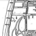
Back when my grandfather was in high school, he used to take girls to the end of South Parkway to “look for German U-boats in the Mississippi.” That was before the creation of President’s Island, which involved cutting off the Tennessee Chute and turning it into McKellar Lake. Unfortunately, you cannot even see McKellar Lake from the end of South Parkway due to the abandonment of the westernmost 1000 feet of the parkway’s right-of-way to the adjacent property owners. If you look on the south side of the street, you’ll see the purpose of this westerly outpost of the parkway system, Martin Luther King Riverside Park. A drive through the park gives you a rare opportunity to see and feel turn-of-the-20th-century landscape architecture at its finest. The golf course in the park recently experienced a major overhaul, similar to the renovations made at Galloway Park. On the north side of South Parkway, you’ll find the rubble of one of Memphis’ great industrial buildings, the sprawling 1924 Ford Motors plant. 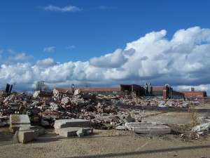
Although Ford had left decades ago, the building survived for many years as a warehouse.
Once you cross over I-55, you’ll see the historic neighborhood of Fordhurst to the right. Fordhurst Subdivision, which derives its name from the nearby Ford plant, was designed on a clean grid system and its homes have held up well through the years. 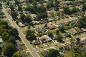
On the opposite side of the parkway from Fordhurst is a series of great industrial buildings from the early decades of the 20th century. The Dixie Wax Paper Company emblazoned their name on their old headquarters. 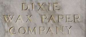 The first traffic signal on South Parkway is Florida Street, where another “Ford” institution lies on your left – the Ford Funeral Home. Once you get past Third Street, the parkway takes on a decidedly residential feel. The verge between the curb and sidewalk is a generous width, which allows mature oak trees to canopy the street. To your right is Shadowlawn Blvd., the main artery of historic Shadowlawn Subdivision. Tidy brick and stone bungalows with massive front porches line both sides of the streets in this area. Shadowlawn Subdivision holds the distinction of being one of the first subdivisions in the city to sport masonry entry features (other early entry features welcome visitors to the Overton Park Place Subdivision on McLean, Belle Air Subdivision on Poplar, Glenview and Morningside Place, the last two of which you will drive by soon).
A light awaits you at Lauderdale Street. Just past Lauderdale, at McMillan, you will find an imposing two-story building standing on the right side of the street; this was the home of the renowned Ellen’s Soul Food Restaurant. Unfortunately, Ellen’s closed a couple of years ago for renovations and temporarily relocated to Elvis Presley Blvd. (just south of Alcy). Hopefully, she will return her culinary delights to the parkway soon. Of interest, before this building housed Ellen’s, it was home to Brady and Lil’s’s Restuarant, which was purchased by Frank Vernon in the early 1980s, who later moved the restaurant to Madison Avenue and gave it a new name – The Bar-B-Q Shop. Traveling further east, there are several more blocks of churches, shops and homes before you will stumble upon the first of many jogs, which make South Parkway unique among its parkway brethren.
The South Parkway jogs. When George Kessler proposed the parkway system to the Memphis Parks Commission in 1901, the South Parkway alignment made it the one parkway that involved substantial right-of-way acquisition since there were few existing roadways in this part of town (East Parkway was largely proposed along Trezevant Street and North Parkway along Summer Avenue). As such, the roadway was laid out as closely to an east-west straight line as possible, but to avoid excessive right-of-way acquisition costs, the parkway had to “jog” around a few large parcels whose owners were probably unwilling to see their property split in half. For the section you have already toured, Kerr Avenue existed for some of the stretch when South Parkway was laid out. Hence, some old maps indicate this section of South Parkway as “Kerr Avenue Speedway.” 
Traveling east, the first jog is Douglass Parkway (yes, for address purposes, each of these jogs has their own names, typically continuing the name of the adjacent roadways).
As you approach the next signal, Mississippi Blvd., look to your left. That BP station is one of the oldest continually operated service stations in the city. Its small size and clean, modern lines reveal its early vintage. Of course, even older filling stations from the teens and 20s line Mississippi just north of the parkway, but none of those are still in use. South Parkway represents the southern end for Mississippi Blvd., which at one time was the preeminent commercial arterial of South Memphis. Just south of the parkway, the last block of Mississippi Blvd. is surprisingly urban in nature, with several brick buildings lining both sides of the street. This urbanity is no doubt the result of the streetcar that ran down Mississippi Blvd. from downtown.
Once you pass Mississippi Blvd., note the well maintained, large brick bungalows on your left, no doubt sustained in part by the anchor of this area, St. Andrew AME Church across the street. Just as you pass St. Andrews, the next famous South Parkway jog occurs. Gaither Parkway, as it is known, can proudly proclaim to be the first location of a median along South Parkway. Similar to the Douglass Parkway jog, Gaither is short and sweet, with landscaped islands separating the travels lanes and the approaches to Gaither Street on either end. When South Parkway returns to its eastward projection, you come across I-240. The cloverleaf at I-240 and South Parkway is one of only two full four-leaf cloverleafs in Shelby County, the other being at Riverside/Crump/I-55. As traffic engineers look less favorably at the effectiveness of cloverleafs, this interchange will likely be altered when this section of I-240 is widened to accommodate the expressway’s duplexing to I-240/I-69.
Immediately after I-240 on your right is one of Memphis’ most venerable restaurants, Coletta’s. Coletta’s has been cooking great Italian favorites at this location for more fifty years. The metal flags that fly over the sign, the Cadillac “V” that frames the sign and the building itself all scream the 1950s. 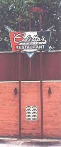 Past Coletta’s, you will come across a wide green area running diagonally on both sides of the parkway. This is the old route of Union Railway, a Missouri Pacific subsidiary built entirely inside the city of Memphis as a belt line. Most sections of the old Union Railway remain, with this section and the section along Chelsea between Thomas and Hollywood being the notable exceptions.
The next traffic signal is Bellevue Blvd. Actually, Bellevue turns into Elvis Presley Blvd. at this very intersection. Look to the right down Elvis Presley Blvd. and you’ll see some good early suburban retail structures. Similar to retail structures along Union Avenue between Kimbrough and Belvedere, these structures were meant to accommodate both the burgeoning automobile clientele, but also be close enough to the street to accommodate pedestrians. Once you cross Bellevue, South Parkway takes a decidedly upper-middle class turn. Long blocks with large bungalows face a median that seems to have gotten wider. Just as you start getting used to things, suddenly, the median disappears. Look to your left, and you’ll see why – the Zion Christian Cemetery, the oldest African-American cemetery in Memphis. Established in 1876 by the United Sons of Zion, a black fraternal organization, the cemetery is now on the National Register of Historic Places.
Once you pass Zion Christian Cemetery, the westbound lanes bump back behind a newly emerged median. You then cross over BNSF RR’s main tracks through Tennessee, and then the lots become much bigger, with the houses duly keeping pace. As with the old Kerr Avenue section of the parkway, a preexisting street existed along this latitude, as well. One early map revealed this section as “Austin Avenue Speedway.” 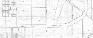
By the way, whether the names “Austin Avenue Speedway” and “Kerr Avenue Speedway” were ever really used is questionable. By 1913, these names were not indicated on a map of the city, but “South Parkway” had not yet been accepted either. “South Park Driveway Speedway” was apparently the preferred name at the time (now that’s a mouthful!). 
Back to the tour, on your left is the Glenview Subdivision, the gem of South Memphis, which comes with a nice masonry entrance feature. Glenview was platted in the early teens, and has remained one of the better addresses within the parkways. To the right are much newer subdivisions, which is evidenced by the ranch homes from the 50s and 60s punctuating that side of the street. Keep a watch out for the attractive stone bridges inside the median at LaPaloma and Castalia Streets. These stone bridges date to the 20s when the culvert was built inside the median. The median through this section of South Parkway is perhaps wider than any other section up to this point in our journey; the parkway has a 200-foot right-of-way in this area (!). South Parkway is about to make its biggest jog yet – and its most exciting.
East Parkway, briefly. As you approach Lamar, South Parkway starts to point northward. A U-turn lane allows you to turn back westward onto the parkway right before you hit Lamar, a feature that is unique on any of the city’s divided roadways. Once you cross Lamar, the roadway has fully transitioned from an east-west to a north-south orientation. And, as with the case with Douglass and Gaither Parkways, you can probably sense a name change is coming. But here’s the kicker: South Parkway East (Florida Street separates East and West addresses) becomes East Parkway South. And if you are accustomed to what images “East Parkway” conjures in your mind, this section of the parkway will not disappoint. Manses from the 20s and 30s line a beautifully landscaped street. From a traffic engineering standpoint, this stretch of roadway is special in that it is one of the few streets in Memphis where lane demarcations are done entirely in those little round reflectors (a la US 101 in California. And just as you start enjoying your surroundings, you come up to yet another jog. Go straight and the road becomes Cooper Street. The Cooper-Young neighborhood is just one block to the north. The parkway, which officially returns to the name “South Parkway,” shoots off to the right. By the way, in the middle of this most unique of jogs is a great traffic circle funneling traffic between Cooper, McLemore, South Parkway East and East Parkway South. The nomenclature of these roadways apparently was a little easier in the past, with the section of South Parkway lining up with McLemore using the name “McLemore Parkway” and the section lining up with Cooper using the name “Cooper Parkway.” 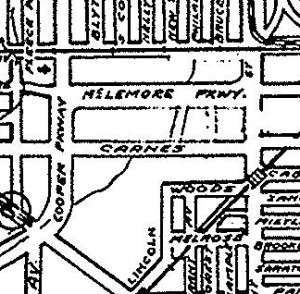
Back to the journey, you have now arrived on the final block of South Parkway. This east-west block has housing very similar to, but not quite as grandiose, the north-south block you just left. One particular house on the left is worth noting: 2170 South Parkway East, which was featured in Johnson and Russell’s Memphis: An Architectural Guide due to its unusual “razzle-dazzle Arts and Crafts” styling. Before South Parkway completely runs out of steam, you will pass by New Salem Missionary Baptist Church on your right, one of the largest congregations in the city of any denomination. The traffic light ahead of you represents the end of South Parkway and the southeast corner of the great parkway system. This intersection between Airways to the right, Spottswood straight and East Parkway to the left, appears to be just like any other intersection in the city at first blush. Traffic whizzes by in all directions. An old plat reveals it used to look muchmore like the corner of a beltway – most traffic traveled from South Parkway to East Parkway and vice versa.
My next post will delve into that roadway to the left, the legendary East Parkway.


Great job, Josh. Looking forward to the next installment. Love the maps & photos.
How long did it take for you to drive this section, while paying enough attention to document the changes?
Another great job, Josh. When this parkway system and parks system were laid out, Memphis was considered a leader in the Progressive Movement of the late 1800s and early 1900s. Seems to us that we have that kind of opportunity again by getting back to the basics, because as you point out, they never go out of style.
Hey John: You can probably take this tour at a reasonable speed (enabling you to look around) in about 20 minutes, but I would suggest stopping by either Coleta’s or the Four Way at Mississippi and Walker for lunch/dinner! -Josh
We’re at Coletta’s for dinner fairly often but disappointed that I’ve never been to the Four Way.
On another note… we need to get some creative graphics person to come up with t-shirt designs for all of the “speedways”. How cool would it be to have a whole series of Speedway/speedwear shirts? Maybe as a fundraiser for something related to the Parkways?
Those t-shirts would be a great fundraiser for Livable Memphis.
Great job….fascinating bit of local history. Thanks for your work. I look forward to further posts.
Josh,
Thanks for raising awareness of the Parkways as one of our great community assets. Our last 100 years of deterioration and underutilization of this asset deserves a place in our hall of shame. A small group of us have been working on an initiative to restore the medians to the Parkways and complete the loop. Let me know if you and others are interested in joining us.
Andy
very enjoyable. great job, josh. looking forward to continuing the journey. thanks
Josh,
Just read the article. Great, Great, Great.
All I can think about is the the fact that you couldn’t stop talking about maps in high school. I’m sure you can imagine the smile on my face the entire time I was reading the article. You were made for this and I couldn’t be happier.
Keep up the good work and I look forward to part #2. That’s always been one of my favorite parts of the city (let’s not talk about our teenage abode..) and I love to see it through your eyes and in abundant detail.
~j